
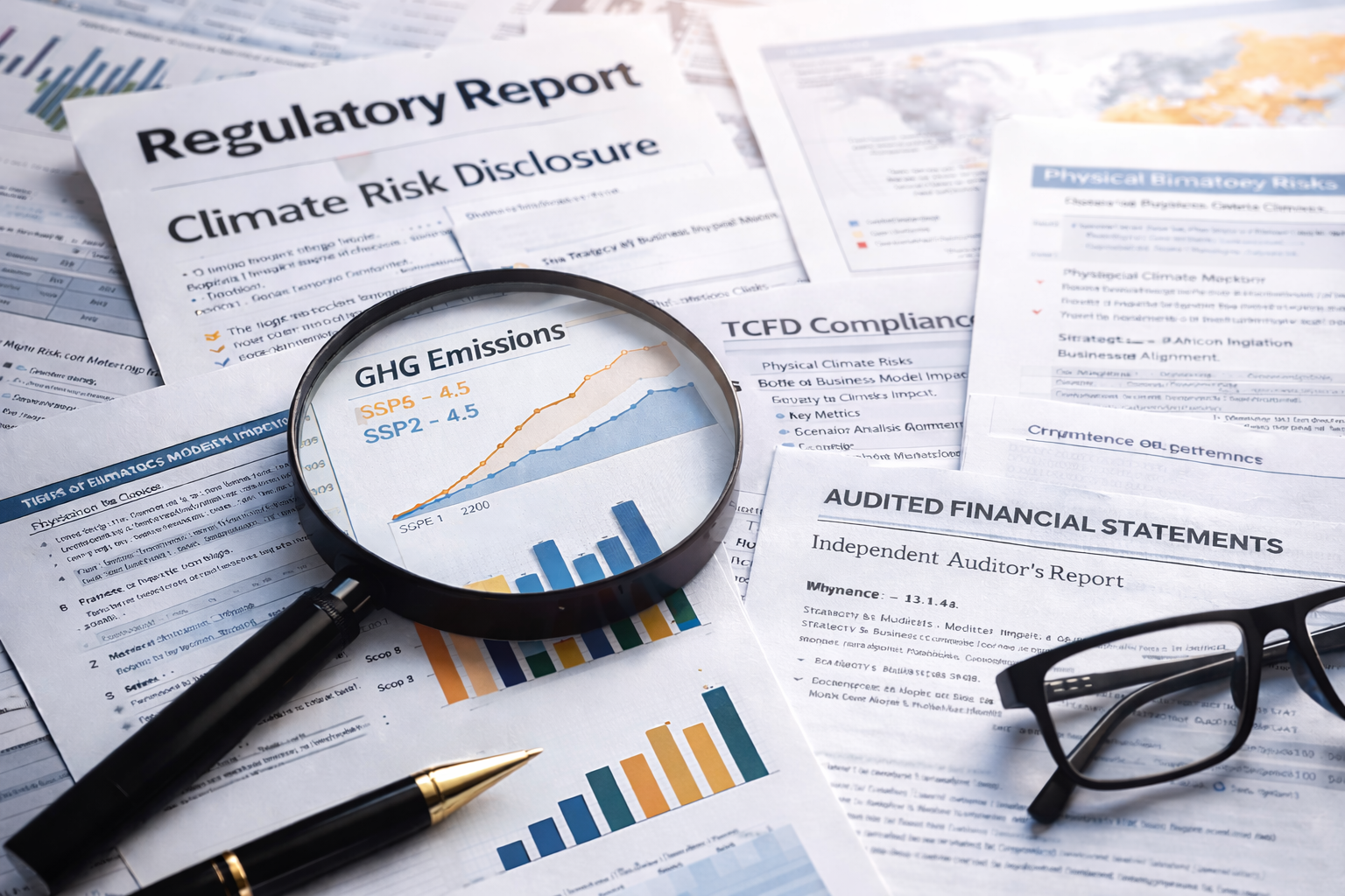

Hazard Information, Risk Categories and Loss Quantification
Climate Risk Grades (CRG)
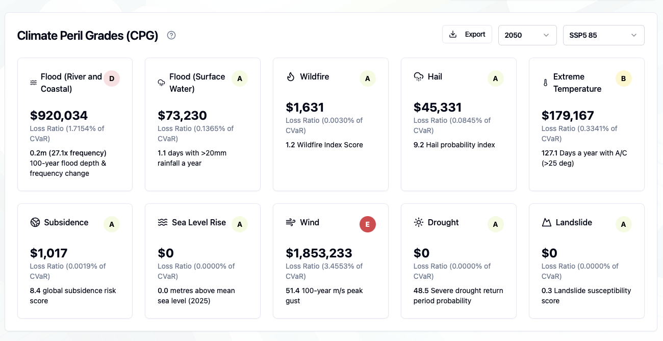
Climate Peril Grades (CPG)
Climate Peril Grades (CPG) are similar to the CRG assessments but are calculated for each individual climate hazard. Climate losses for any single location, or group of locations (e.g. a portfolio) is categorised into a letter grade (A-E). ‘A’ grade properties are considered the lowest risk.
The key difference with CPG peril grades is that losses are accumulated for individual perils and then divided by a share of the overall exposure based on the number of modelled perils. The corresponding ADR (Annual Damage Ratio) value assigned to the property or portfolio is then given a letter grade.
CPG (ADR%) = Annual Loss from 1 x Climate Peril /(Total Exposure/No of Perils)
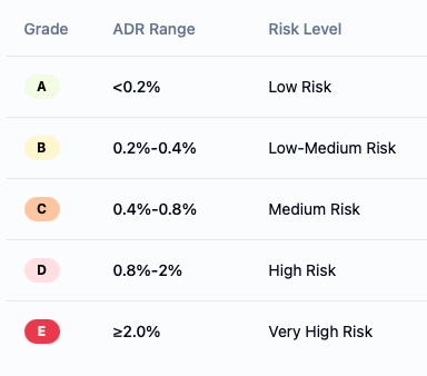
ADR values are then assigned a CRG letter grade as the table shows. Structures with ADR values > 2% denote an expectation that the location is at very high risk and may experience losses equivalent to 2% of the properties value a year.
.
The purpose of the Climate Risk Grade (CRG) is to categorise the accumulated loss for any single location, or group of locations (e.g. a portfolio) into one of five letter grades (A-E). ‘A’ grade properties are considered the lowest risk.
Letters grades are based on the ADR (Annual Damage Ratio) value assigned to the property. The ADR values is calculated using the following equation;
CRG (ADR %) = Total Annual Loss from ALL Climate Risks / Total Exposure Value
ADR values are then assigned a CRG letter grade as the table shows. Structures with ADR values > 2% denote an expectation that the location is at very high risk and may experience losses equivalent to 2% of the properties value a year.
Please note, it’s important to be aware that ADR values are an annual loss estimate only and the property may incur much greater loss than this (in any single year) or much less than this. It is a conditioned statistical average only and should be treated as a consistent measure of risk.
Hazard Scores
Loss p.a / Average Annual Loss (AAL)
Tempest provides an estimate of the expected losses per annum for every location, hazard, climate time horizon and scenario. This term is also known as the Average Annual Loss (AAL), Expected Annual Loss (EAL) or Losses Per Annum (Loss p.a.). It is calculated for every location and hazard but can then be aggregated to report losses at a portfolio level or based on a custom filter of your choice (e.g. by country, supplier).
Tempest bases annual loss reporting on multiplying an ADR (Annual Damage Ratio %) by the estimate of the property’s respective building, contents and business interruption exposure.
Annual Loss = Annual Damage Ratio (ADR) * Building / Contents / BI value
Users can then report on the losses for different combinations of all three coverages (Building / Contents / BI).
Please note that Tempest Annual Losses are not calculated using a stochastic event set in the same way that a reinsurance probabilistic model would estimate this value. Reinsurance CAT models simulate thousands of events, modelling each footprint and producing a catalogue of losses (Year Loss Table) from which annual losses and probabilistic losses are derived. Tempest uses pre-computed probabilistic hazard assessments (e..g 1-in-100 year Flood) to estimate the loss at the 100-year period and divides this value by 100 to give an annual indication of loss.
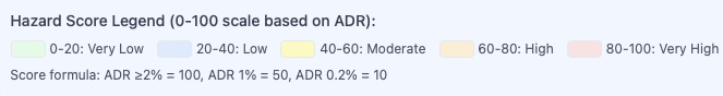
Hazard Scores provide more information than the CRG’s on the severity of risk for each location. These scores range between 0-100 and are calculated for every location and every hazard analysed. Tempest uses a scoring system based on the ADR (Annual Damage Ratio) value being assigned a proportional hazard score with a maximum value of 100. ADR values with 2% values or higher are all given a hazard score of 100. All scores below this are standardised as follows;
ADR %) = Converted to a score between 0-100
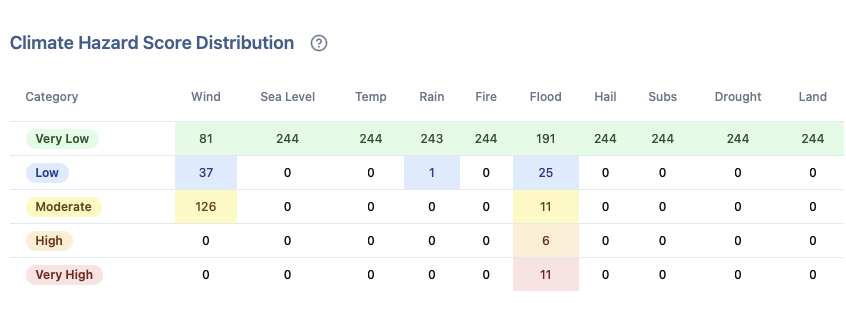
Climate Hazard Scores are found in both the ‘Tables’ view of the dashboard as well as in the ‘Reporting’ view, which has a table entitled ‘Climate Hazard Score Distribution’. This provides an overview of how distributed a portfolio is, and which score categories your portfolio locations fall into.
Please note, it’s important to be aware that Hazard Scores are an annual loss estimate only and the property may incur much greater loss than this (in any single year) or much less than this. It is a conditioned statistical average only and should be treated as a consistent measure of risk.
Climate Hazards Modelled
The Tempest platform models the impacts of multiple global climate hazards from 2026-2100 with estimates of decadal changes.

Hazard
100- year Flood - This includes explicit modelling of River (fluvial), Flash (pluvial) and Coastal (storm surge) flooding. Flood data from commercial vendor JBA Risk Management is used to model each peril separately.
Depth (m) - Flood depths at any location in the world are estimated and linked to a level of hazard intensity. While duration and flood velocity can impact damages to property and natural capital assets, depth shows the highest correlation. Tempest links the depth to an associated ratio of damage.
100- year Wind - This hazard includes analysis of both Global Tropical Cyclones and European Extra-Tropical Cyclones (ETCs). Tropical Cyclones is an umbrella term that also encapsulates all forms of these events including Hurricanes in the US and Typhoons in Asia. From a meteorological perspective, both storm systems have the same characteristics. Extra-Tropical Cyclones are commonly referred to as mid-latitude or European Windstorms. While ETCs occur in many places in the world, only European storms are included in the Tempest model.
Hazard Metric / Damage Assessment
Windspeed (3 second peak gust in m/s ) - Peak gust is the primary driver of property damage during windstorm events. While sustained wind speeds are highly correlated to losses, research shows that damage to buildings occurs during phases of wind gusting. Both 2 second and 3 second peak gusts are common measurements for cyclones. WMO conversion factors were made to model both perils using the same metric to ensure consistency. Tempest links the higher 100-year windspeeds to relative ratios of damage.
Sea Level Rise - Dynamic Sea Level Rise incorporates key factors influencing ocean water levels. This includes thermal expansion (warmer waters expand), isostatic changes (as land adjusts to the loss of ice), glacial meltwater and ocean currents. Baseline sea levels in the model for any location are treated as being ‘0’ in 2026. This is to provide a relative baseline for future increases. Therefore, locations modelled for sea level risk in 2026 will always show no losses.
Relative rise in metres from 2026 - Sea Level rise is estimated from an ensemble mean of CMIP6 models. Coupled General Circulation Models provide a global picture of how sea levels are projected to change through the 21st Century under a range of alternative Shared Socioeconomic Pathways (SSPs). Tempest links inundation depth of sea level rise to an associated ratio of damage.
Wildfire - Wildfire Risk is characterised through a globally calculated index. This methodology uses multiple ERA5 data sources including temperature, humidity, precipitation and fuel load to formulate a global risk index value. Future Fire Risk is then based on CMIP6 projections of how the Wildfire season may vary in length in the future.
Index - A composite index is used (based on the Canadian Wildfire Index methodology). This value is then adjusted based on future time horizons and scenarios. Tempest links higher Wildfire Index values to higher ratios of damage.
Drought- Periods of drought are defined by using the 12-month Standardised Precipitation Evapotranspiration Index (SPEI). This standard method monitors shifts in precipitation and evaporation to help identify when locations become water stressed. Periods of drought are typically when the SPEI drops below a negative threshold for several months.
Event Count - A count of drought events has been modelled by analysing periods when the SPEI index drops below a threshold for four consecutive months or more. Counts of these events have then been modelled in 30-year time windows for multiple SSPs and a historic baseline. Each Drought is associated with a projected level of impact (particularly for business interruption).
Landslide - Landslides can be a consequence of both tectonic and weather-related causes. Tempest uses a Landslide susceptibility index based on assessment of global topography (to identify slope angle/instability). tectonic risk (using earthquake source trigger information and regions of intense precipitation.
Index - A landslide index value associates regions of higher risk with higher damage potential. The Tempest fragility curve makes this association.
Subsidence - The repeated shrinking and expansion of clay rich soils can result in land subsidence. The impact of this process can undermine the structural foundations of properties and cause damage. Source datasets used in the Subsidence Risk Index include aquifer and groundwater extraction, and global soil and geology profiles to identify regions of higher risk.
Index - Tempest has a global hazard dataset of alternative subsidence values associated with different risk levels. Each level of the index is associated with a defined probability of loss.
Temperature (Hot Days) - Energy use is required to run A/C units around the world to cool both commercial and residential premises. Increasing ‘Hot’ days in the future will result in proportionally more energy use costs to maintain temperatures.
Count of Days above 25 degrees C - Tempest uses a threshold of 25 C as when AC units will be switched on. Counts of these days are modelled from the CMIP6 models and then associated with increased costs.