
Is your business prepared for the 2026 ‘Super El Niño’?
El Niño Southern Oscillation (ENSO)
In June 2026 world meteorological agencies declared that we are rapidly heading into an El Nino climate phase – a period where sea surface temperatures in the Eastern Pacific drive a global pattern of extreme weather estimated to cost the world over a trillion USD in direct and indirect damages. From widespread floods and wildfires to deadly droughts and tropical cyclones, this Tempest feature explores what a ‘Super El Nino’ pattern of weather could mean for different regions and business sectors around the world. What are the risks and what can global risk managers do to prepare? From agricultural impacts in Australia and India to the indirect impacts of on European apparel, we examine the diverse and wide-ranging connected potential climate impacts of a ‘Super El Niño’.
What is a ‘Super’ El Nino?
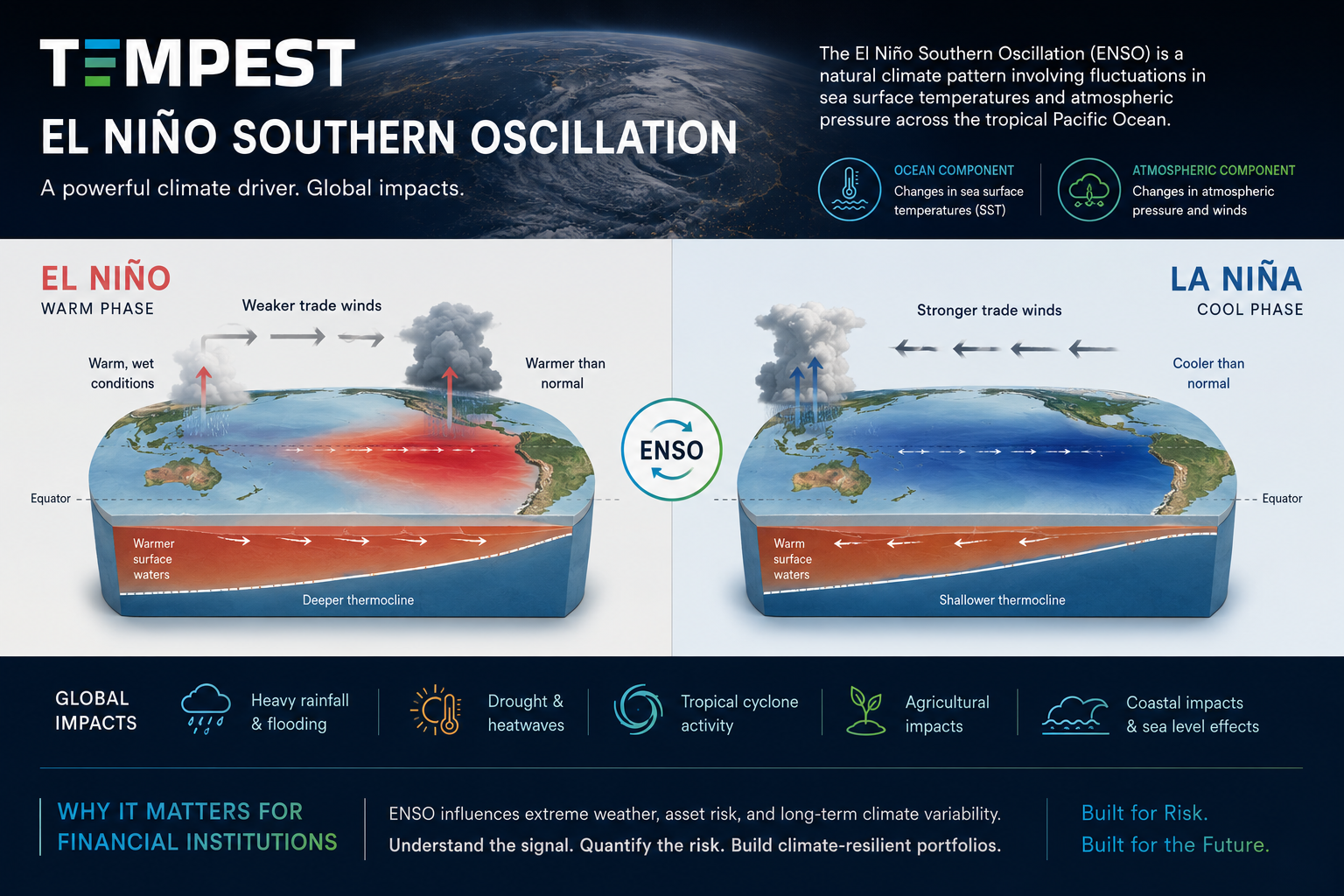
In essence, a ‘Super’ El Nino is an unofficial term for a very strong positive phase of the El Niño-Southern Oscillation (ENSO) - the global weather phenomenon that emerges from wind and sea surface temperature variations in the Pacific Ocean. The influence of ENSO on the global climate is vast and varied, but there are two very distinct phases; El Nino, and its’ counterpart, La Nina. Each characterised by differential warming of the Pacific Ocean.
La Nina occurs when sea surface temperatures (SST) in the Western pacific are much warmer than the average (defined by their comparison to a Pacific average, such as central Pacific areas like ONS 3.4). The temperature anomaly is given an index value, with negative ENSO values corresponding to La Nina and positive values denoting warming of the Eastern Pacific Ocean and representing El Niño. If either positive or negative values are sustained for consecutive months above a given threshold (e.g. +/- 0.5 degree C), an El Niño or La Niña phase is declared. One key point to note here is that average ocean temperatures globally are rising so rapidly in recent years that there is ongoing scientific debate on how best to record future ENSO phases, with a growing consensus that using the relative ENSO index may be a more appropriate way of characterising the positive phases.
On the 2nd June 2026, the World Meteorological Agency cited an 80% probability of an El Niño weather pattern emerging between June-August. Climate models predict that the temperature anomaly will breach +2.0 degrees in the coming months. This degree of temperature anomaly is rare, and while an unofficial term, some meteorologists refer to it as a ‘Super’ El Niño.

Sea Surface Temperatures (SST) Nino 3.4 Index, 2019-2026 (Data source: NOAA 2026; Graphic: Tempest Risk)
Climate Impacts
In order to understand the diverse impacts of an El Niño weather pattern, it’s firstly important to understand how it acts to weaken, and even reverse existing weather patterns such as the ‘Walker’ circulation. The Walker cell regulates weather in the Pacific and generates the trade winds. The warmer ocean temperatures in the Eastern Pacific from El Niño disrupt these trade winds, resulting in higher air pressures to form in the Western Pacific Ocean. In the feedback loop, warmer water continues to build in the Eastern Pacific and reduces the deep ocean upwelling that would normally cool ocean temperatures in this region. This results in reduced rainfall over Indonesia and large areas of Northern Australia. Simultaneously, the warmer Eastern Pacific Ocean temperatures increase cloud formation and rainfall along South American coastline. This results in more cloud formation and increased rainfall. A key characteristic of El Niño weather is that more favourable conditions begin to develop for Tropical Cyclone formation in the Pacific. Conversely, hurricane activity in the North Atlantic can become muted due to increased wind shear.
On average, they occur roughly every 2-7 years. While El Niño phases are irregular in occurrence, once established, they can last several years. It’s estimated that since 1900 there have been 30 El Niño events. The table below highlights the three most economically damaging ‘El Niño’s of the last 50 years.
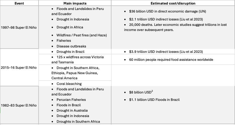
Historic El Niño events and the estimated global damage / disruption
What’s notable from separate El Niño events of 1982, 1997, and 2015 is a similar pattern of acute perils such as floods and landslides in South America, and repeated droughts and wildfires of Indonesia, Australia and Southern Africa. While the direct damages attributed to the 1997 El Niño totalled $36 billion (UN), economists estimate the cascading impacts of these events on global food security, infrastructure and business are closer to $3.9 trillion USD (Liu et al, 2023).
The table below summarises key concerns for business and what global risk managers will be paying close attention to in the year ahead. Sectors have been mapped to show the vulnerable regions and elevated climate extremes that previous El Niño events have impacted. As well as the acute (fast-onset) risks of floods and landslides, El Niño events have the capacity to create chronic events such as catastrophic droughts and famines.

Sector mapping regions vulnerable to a ‘Super El Niño’
The globalised nature of trade and industry is why El Niño events can be so costly to business. While European and North American business may consider these events as remote and unconnected, ENSO phases have far reaching impacts across multiple sectors. Previous events have devastated regions of South America through floods and landslides, while extreme summer temperatures in Australia repeatedly trigger wildfires and drought. Similarly, distal regions such as South Africa and India routinely experience dramatic reductions in rainfall during El Niño, impacting non-irrigated crops and driving crop failure. Aside from the direct impacts on Agriculture and Real Estate, second order impacts make other sectors vulnerable. A fall in Tourism due to heat stress, wildfires and haze are very real impacts for countries across South East Asia. Mining operations vulnerable to flooding and landslide risk during El Niño as well as impacts on key trade choke points. The Panama Canal drought of 2023 was triggered through unusually low rainfall and resulted in a 30% drop in shipping trade. While the climate risks are significant and widespread, there are still practical steps that businesses can take to safe guard themselves during a Super El Niño. At Tempest we’ve developed a 10-point checklist for risk managers and business leads to help prepare, adapt and build resilience for the coming year.
10 x Steps for Risk Managers to Prepare for a Super El Niño
Model El Niño hot spots for your business- While El Niño can indirectly impact weather almost anywhere in the world, there are key geographic regions and climate perils that climate risk models such as Tempest Web that can help businesses identify vulnerable property assets. This could include mapping the wildfire risk of manufacturing facilities and critical suppliers in Australia, or the flood and landslide risk to key customers and distribution sites in South America. If any of these locations flag as having a high risk already, be aware that the risk probability is likely be elevated during a Super El Niño.
Understand your Tier 2 supplier exposure as well as Tier 1 - Where do your suppliers source their raw materials? If they have an underlying dependence on regions that are readily exposed to El Niño climate impacts, it is very likely to impact your business. For example, El Niño has been shown to weaken the Indian summer monsoon in previous events. This can directly impact agricultural production for key crops such as rice and cotton. A shortfall in cotton yield this year could inadvertently impact global apparel and highstreet retailers. By modelling Tier 2 suppliers in platforms like Tempest businesses can understand supply chain connections to high risk commodity crops or raw materials. In turn, they can get ahead of the market by making redundancy plans or diversifying their supplier network.
Quantify Revenue at Risk - not just asset exposure - Risk managers should work closely with procurement and finance executives to understand their revenue exposure due to El Niño. While a particular asset may have a more severe risk of wildfire, flooding or landslide, the more critical asset for profitability to your business could be a location with lower physical risk but much higher revenue at risk. It may be these locations that you should be most concerned about and review their safety and adaptation potential. For example, do the buildings have adequate Wildfire spacing or flood defences if they’re in a high risk zone. The automated Tempest reports let users model their ‘revenue at risk’ for different climate perils for all global assets.
Stress Test critical scenarios - Run plausible ‘what if’ scenarios to test your resilience against El Niño. For example, if the Panama Canal becomes restricted again due to El Niño and causes another 30% drop in shipping containers, how will this impact your business? Are you reliant on this route? And if so, how long before it materially impacts your own customer deliveries? Or perhaps your Tourism business takes customers to Singapore and Indonesia but there is growing concern that the peat and wildfire haze will once again impact these countries, making it dangerous to be outdoors in the polluted air for any length of time.
Reassess your Business Interruption (BI) and Contingent Business Interruption (CBI) cover - Double check exactly what your insurance covers you for to avoid protection gaps. While your Business Interruption insurance will cover you (up to a limit based on lost earnings from an event) for directly owned or managed assets, Contingent Business interruption (CBI) allows you to be protected from the external shocks of supplier exposure. However, CBI terms are very specific - the suppliers usually need to be named in the policy and it’s generally treated in the policy wording as an extension to Business interruption. For example, if you bought BI wildfire protection but not flood cover, your CBI extension would cover your exposure to wildfires at supplier sites but not flood risk.
Second order impacts - As well as the fast onset (acute) perils, El Niños are trillion dollar loss events due to the multi-year impacts and cascading effects they have across the world. While this El Niño may not impact your bottom line this year, it could be that in 2027 your business is impacted by the gradual impact on your supply network through localised water restrictions, worker heat stress, transport disruption, port congestion and crop failures that eventually hit profitability.
Climate Monitoring - Every El Niño and La Niña event is different. In both their severity and how long they last. Businesses can work with advisors and agencies to develop pro-active, mature risk programmes to actively monitor the ongoing El Niño. Key attention should be given to climate predictors such as sea surface temperature (e.g. Niño 3.4), reservoir levels, wildfire danger indices, global trade indicators and stressors (e.g. Global Supply Pressure Index).
Build resilience before the event - Preparedness is key for any Chief Risk Officer or Manager. Businesses can prepare for El Niño by ensuring a range of practices have been put in place to safeguard operations. This may include one or more of the following options; duel-sourcing critical materials, increased inventory (or stockpile) of vulnerable components, diversity transport routes/options, and securing back-up manufacturing options.
Work with suppliers to develop resilience - Building resilience is best done by working with your suppliers. If you’ve identified a vulnerable supplier, work with them to understand how they’re exposed, what could realistically happen (worse case), and how can you work together to protect this critical artery of your business. It could involve a range of measures such as increasing production in the short-term to protect inventory or perhaps identifying alternative transport routes known to be vulnerable. By working with suppliers such plans are likely to identify and manage the key risks more effectively.
Use IPCC Climate Scenarios (not just historic El Niño data) - The past is a very useful predictor of the future but it’s equally important to consider that the climate is now 1.47 degrees warmer than it was pre-industrial, and therefore, future El Niño impacts may be far more severe than the recent historic events of 1982, 1997, and 2015. For this reason, we’d also recommend using IPCC Climate Scenarios from 2026-2100 to stress test property portfolios for potential damages under IPCC scenarios. At Tempest, our models cover a range of IPCC scenarios using CMIP6 climate models to help clients understand future climate impacts.
This feature was written by Dr Iain Willis, Tempest Risk Co-Founder. For more information on how to access the Tempest Risk platform or climate risk services please contact info@tempest-risk.com.
Sources
World Meteorological Agency - https://wmo.int/resources/publication-series/el-ninola-nina-updates/el-ninola-nina-update-may-2026
Nonlinear El Niño Impacts https://pmc.ncbi.nlm.nih.gov/articles/PMC10514271/
NASA El Niño - https://science.nasa.gov/earth/explore/el-nino/